Chapter 1
Speculative Prehistory of Humanity
2THE DYMAXION WORLD MAP shows one world island in one world ocean with no
breaks in the continental contours and with no visible distortion of the relative size or
shape of any of the cartographic patterning. See map on page 399.)  Change: Fix ref to Map The coloring on the full-size map is that of the
optical spectrum, with red representing the hottest climates and dark blue representing
the coldest climates.
Change: Fix ref to Map The coloring on the full-size map is that of the
optical spectrum, with red representing the hottest climates and dark blue representing
the coldest climates.
3 The borderline between yellow and green is the freezing line. The color shown for any area of the map represents the coldest conditions for that geographic area. Verkhoyansk, in northeastern Siberia, is the cold pole of planet Earth’s northern hemisphere. Yet, sometimes in August at noonday, Verkhoyansk is as hot as equatorial Africa. Frequently in midwinter Verkhoyansk’s temperature falls to sixty-five degrees below zero Fahrenheit. Equatorial Africa rarely has a temperature at midwinter of less than seventy degrees above zero Fahrenheit. The annual temperature variation between the hottest and coolest in equatorial Africa is only twenty degrees Fahrenheit, while the annual variation at Verkhoyansk is 120 degrees Fahrenheit.
4 The vital factor that determines social patterns, human preoccupations, and economic customs of those dwelling in different geographic environments depends on how cold it gets, not on how hot. With their shade-making artifacts humans can live nakedly under the hottest of Earth’s weather conditions. Consisting physically of 60 percent water, humans cannot live nakedly where it is cold—not below the freezing line of thirty-two degrees above zero Fahrenheit.
5 The Dymaxion Map shows that (1) the colder an area gets, the more the annual temperature variation, and (2) the more the geographical temperature varies annually, the more inventive the humans who live in those areas have to be to survive. If you live by Lake Victoria in eastern Africa and you wish to cross it, you will invent a wooden boat. If you live beside Lake Baikal in central Siberia and you wish to cross that body of water, you will invent a wooden boat in the summer and skates and sleds in the winter. The people who live in the colder areas are not more inventive—the y simply have many more environment-caused occasions in which to employ all humans’ innate inventiveness. Move humans from a hot country into a cold country, and they become as inventive as those who live there—or they perish.
8 As flying insects are hit by the windshields of our speeding automobiles, their intricate wings, legs, sensors, and bodies splash out as flat, yellow-green blobs. More than 50 percent by both volume and weight of the average physical structure and mechanics of all biological species consists of water. Humans’ structuring and integral organic equipping is over 60 percent water. Earthians are hydraulically designed technologies.
9 All structures consist of a balanced interaction between tensive and compressive forces. Nature services all her tension functions rigidly with three crystalline, maximum-cohesion bonds, and services her compression-resisting functions with double-bonded, flexibly hinged, variously viscous hydraulics. These are non-compressible, but being flexible, they distribute their loads evenly to all the surfaces of their triple-bonded, tensional-container systems. As long as the triple-bonded tensional crystalline’s containers are strong enough, the hydraulic structural system will hold its tensionally fill the designed container, are non-compressible.
10 Because water is essential to all the biological organisms’ ecological system of regeneration on our planet, the major facts about it are vitally relevant. pre-designed, optimally extended shapes because the contained liquids, which entirely
11 Vital fact number one (as already stated) is that biological life is 50 percent water.
12 Vital fact number two is that we don’t know of any water in Universe other than that on our planet Earth. Almost three-quarters of the Earth’s surface is covered with water. The water coverage averages in depth the length of a vertically suspended chain consisting of 2000 head-to-foot-linked humans. The world’s oceans seem so deep to people that the amount of water in Universe is thought of by them as unlimited. But on a twelve-inch-diameter Earth globe the proportional depth of the ocean to Earth’s diameter would be only three one-thousandths of an inch, which means that the absorption depth of the blue ink into the thin paper cover of the globe upon which the oceans are printed is far deeper in respect to the miniature Earth globe than is the real world ocean in respect to the real Earth’s globe.
13 Vital fact number three is that water freezes and boils within close limits. Anywhere in Universe except inside Earth’s biosphere the water (of which we too consist) would be either frozen, boiling, evaporated, or incandescent. These facts integrate to tell us that our terrestrial biosphere is a unique environment essential to the survival of human organisms, not only on our planet, but anywhere within the thus-far-discovered Universe. To keep humans alive outside our biosphere requires reproducing and maintaining our exact biospherical conditions within a physically powerful and superbly insulated, into-space-rocketable container.
14 Before the continental networks of reinforced-concrete highways commenced half a century ago, human civilization, as seen from a low-flying airplane, was always strung out along the brooks, rivers, ponds, lakes, seas, and oceanfronts. Vast real estate developments and their under-ground-hidden, long-distance pipelines now tend to obscure this absolute dependence of humans upon water.
15 Vital fact number four is that water gains and loses heat more slowly than any other known profusely available substance. The South Pacific and Indian Ocean atolls were formed on the ocean-surface rims of both extinct and active volcanoes, broken through the ocean bottom crust of the Earth. The volcanoes and the radiation from the Sun brought the water temperature to a level compatible with humans’ normal 98.6 degrees Fahrenheit, and the tropical ocean’s temperature was maintainable thereafter by the Sun alone. The world ocean’s thermal stability keeps the world’s temperature changes at minimum.
16 All humans in all history have always been born naked, helpless for months, hungry, thirsty, curious, and ignorant. They could not have survived if born where they would freeze, be dehydrated, or burn to death. The most logically propitious place for humans to survive and prosper within our planetary biosphere was on the coral atolls of the South Pacific and North Indian oceans. Here the barrier reefs effectively intercepted the great seas. The temperature of the almost-still water inside the lagoons was so compatible with life that head-above-water humans could stay in them continuously without any unfavorable effect. The lagoons abounded in fish, and there were mildly sloping, easy-to-walk-in-or-out-upon beaches of white sand. Crystal fresh waters poured down the mountainsides, and coconuts full of milk fell to the ground around the humans. Fruits were plentiful, and there were no wild animals threatening to eat the helpless baby humans.
17 Discovering that they themselves could not drink the salt water, these island-atoll people soon learned that the edible vegetation and fruits grew only from fresh water and Sunlight. Noting that the fresh water came either from the sky or from springs, the atollers came to invent shoal, freshwater-paddies-filling, parallelly contoured, intertiered-one-above-the-other terraces at human-waist-height distances above one another. This terraced water-ditching started high on the hillsides. Down and through this interdammed valving the fresh waters slowly flowed—so slowly as to usually appear to be motionless. Ultimately they leached into the sea.
18 The atollers made small and large freshwater vessels of animal skins, wood, and stone—vessels that held water inside and dug-out log vessels that excluded the water. Living half in the water, they became natural hydraulic inventors.
21 It is relevant to our speculative prehistory reviewing of all known clues that, in common only with water-dwelling mammals such as whales and porpoises, humans shed salt water tears, as do none of the other primates.
22 Marrying a fast-running horse with another fast-running horse increases the mathematical probability of ‘‘concentrating’’ the fast-running genes-ergo, has high probability of producing an even faster-running horse, which high-bred needs much care, having lost its general capability to cope with the wide range of hostile environmental events.
23 Through the mathematical probability consequent to sorting out and concentrating special behavioral-capability genes and isolated pairing and inbreeding of parents manifestly rich in those special physical capabilities, we humans have learned how to accomplish the development of ever-more-highly-specialized biological species. We note that inbreeding of special, frequently employed capabilities has always been accomplished only at the cost of out breeding general adaptability to cope with the infrequently occurring, high-energy-concentrating events. Humans geographically isolated for many generations (for instance, in a high-mountains-enclosed valley), inevitably inbreed those of their numbers most successfully and lengthily surviving under those special environmental conditions because the surviving types are the only ones left with which to cohabitate. This automatically concentrates the most favorable genes for local survival.
24 The highly inbred progeny become specialists in surviving under the locally prevailing special-environmental conditions.
25 We have no experimental evidence of successfully interbreeding highly divergent special biological species and their unique capabilities to produce completely effective general adaptability. If, on the other hand, we continued successively to inbreed generation after generation of champion Olympic gymnasts, we would soon come to super-inter-tree-jumping-and-swinging monkeys with no more intellectual talent and general-adaptability useful-ness than that of the bright chimpanzees.
26 For this and other persuasive reasons my speculative prehistory has assumed (since 1927) Darwin’s evolution of life from the simple to the complex, accomplished through progressive agglomeration of single-cell amoebas, to be in reverse of the facts.
27 When Darwin was a young man, at the time of the voyage of the Beagle, Dalton was among the world’s leading physicists. Mendeleyev’s periodic table of the elements had not as yet been conceived of. Dalton favored the concept that all atoms were produced by combinations of the hydrogen atoms. This concept and Darwin’s single-cell concept fitted neatly into humanity’s propensity for looking for ‘‘THE building block of the Universe’’—people’s imagination is childishly stimulated at the idea of finding ‘‘THE KEY.’’ Spontaneously, we are simplistically inclined—it feeds the ego. ‘‘Oh, boy! If I had the key—what couldn’t I do?’’
28 Today it is eminently clear that human beings’ physiological composition consists of a relative abundance of the ninety-two regenerative chemical elements’ atoms similar to the relative abundance of chemical elements in Universe, which Universe consists of a plurality of individually unique generalized principles. In 1922 came physics’ demonstration of a fundamental complementarity of inherently different components of physical phenomena. In 1956 the Nobel Prize in physics was given for the proof that the complementaries were not ‘‘mirror images’’—one of the other. The number of chemical elements present in the amoeba will not accommodate the chemical elements’ complexity of Universe. Universe is inherently complex and eternally regenerative. It can have no ‘‘beginning’’ or ‘‘ending.’’ Vast numbers of scientists as yet labor vainly to account for the misconception of beginnings and endings. We have at minimum the neutron and the proton, which always and only coexist, the electron and the positron, the neutrino, antineutrino, and all. There is no single building block—the re are only complexes of complex systems.
29 As the great mathematician Leonhard Euler discovered with his topology, all visual
experiences consist of three inherently different and unique phenomena: (1) lines; (2)
when lines cross, we get vertexes (corners, fixes, points); (3) when several lines
intercross, we get an area (window or face), or, as we call them in synergetics: (1)
trajectories, (2) crossings, (3) openings. (See §§1007.11-15, Synergetics,
vol. 1; §§1007.22-31, Synergetics, vol. 2.)  Change:
Add to bibliography A system divides all of the Universe into (a) all of the
Universe outside the system, (b) all of the Universe inside the system, and (c)
the little bit of remaining Universe which comprises the system that separates
the macrocosm from the microcosm. The minimum system of Universe (4) is
complex—four corners, four windows, and six edges. ‘‘Thank you, Euler—that will do,
Darwin.’’
Change:
Add to bibliography A system divides all of the Universe into (a) all of the
Universe outside the system, (b) all of the Universe inside the system, and (c)
the little bit of remaining Universe which comprises the system that separates
the macrocosm from the microcosm. The minimum system of Universe (4) is
complex—four corners, four windows, and six edges. ‘‘Thank you, Euler—that will do,
Darwin.’’


37 We see it as highly feasible to have tele-scanned from elsewhere in Universe the DNA-RNA-like coding of a complex angle-and-frequency programming together of terrestrially occurring chemical elements into their molecule-combining chemistries to successively produce a variety of species such as trilobites, dinosaurs, etc., as a progression of elsewhere-controlled Earth-landing tests. We see it as also highly feasible that these landings were used to discover the most suitable types of local-in-Universe information-harvesters and problem-solvers. The critical-limit experiences of the successive creature landings we see thereafter being sent back to some cosmic headquarters, thereby to guide the improvement of the design of the landings of thick-skinned creatures able to cope with greater annual temperature ranges than are humanly tolerable. And after further millions of years have passed and the environmental conditions have become auspicious, we see it becoming feasible to telescan the assembling of humans on Earth, thereafter inbreeding some of them into the ape stages.
38 We can comprehend how South Sea-atoll, lagoon-frolicking male and female human swimmers gradually in-bred pairs of underwater swimmers who held their breath in their lungs for ever-longer periods, and after many inbreedings of largest lungers and as many outbreedings of general adaptability organic equipment, the progeny evolved into porpoises and later into whales.
39 Intimately relevant to these fundamental reorientings of our speculative prehistory of humans present aboard planet Earth, we have the following hard-fact scientific discoveries:
- 1.
- Vitamin D from Sunlight is essential to humans because milk-provided calcium is essential to the human bone
- 2.
- structure. Vitamin D functions in the conversion of calcium into bone structure.
- 3.
- Humans synthesize vitamin D through the action of the Sun’s ultraviolet rays on the skin. This biochemical function is a zoological counterpart of botanical photosynthesis of Sun radiation into hydrocarbon
- 4.
- molecules.
- 5.
- But vitamin D is one of those vitamins of which humans can have an overdose.
- 6.
- In warmer and tropical climes, where vitamin D from the Sun is adequate or excessive, humans’ subconsciously
- 7.
- functioning organisms, employing their chemical process options, develop Sunlight filters in the skin
- 8.
- consisting of darker and darker pigments, which prevent excess absorption of radiation and avoid the overdose of vitamin D.
- 9.
- Where there is not much Sunlight, as in the Far North, human organisms had to progressively remove their skin
- 10.
- pigment filters, which left only blond skin permitting maximum synthesis of vitamin D from the Sun.
- 11.
- Vitamin D is not naturally present in most foods. The one food in which it is significantly present is whale blubber—a food of the Eskimos. Because of long periods of darkness and the large amounts of clothing the Eskimos wear to protect them from the
- 12.
- cold, Sunlight-synthesized vitamin D is not available in enough quantity to the Eskimos.
- 13.
- The two chief, human-organism-supplied skin pigments that filter the Sun’s rays
are:
40
41Melanin: brown and black skin
42Carotin: oriental (yellow) skin 1
44 In confirmation of all the foregoing we note the white and pink skin bottoms of the feet and palms of hands of otherwise dark or black-skinned individuals—white because not exposed to Sun and therefore unable to photosynthesize vitamin D from the Sun, therefore not protectively colored by melanin or carotin filters.
45 Biology demonstrates a botanical counterpart of the foregoing zoological Sun-utilizing and -filtering strategies for the Sun-intensity filtering strategies manifest in the Earth’s hardwoods. The most northerly are white oak, southward of which we come to the pink oak and light-yellow birch. As we go farther south, we see the pink pearl maple and gray ash, then the deep red-yellow southern pine, south of which occur the brown mahoganies and dark-gray teak, and farther south the dark-brown rosewoods, with the spectrum change terminating at the Equator in the black ebony.
46 Compound this information with the fact that only for the last short decade in all of human history have we learned through incontrovertible scientific evidence that undernourishment of a child during its gestation in the womb or in its first year of life most frequently results in damage to the human brain. The damage may often be just a mild dulling or slowness of wit of an otherwise seemingly healthy human.
47 Throughout all known history the powerful fighting kings and noble stock reserved exclusively to themselves all animal flesh derived from their hunting. The poor people had to make do with the local roots, nuts, and fruits, which, due to vagaries of special environments, often contained a range of chemical ingredients inadequate to healthy nourishment. The animals, on the other hand, ate of the vegetation in general and of other animals’ flesh, sum-totally acquiring a comprehensively broad input of the full gamut of chemistries essential to a healthy diet.
48 Karl Marx, bespeaking the workers, assumed the working class to be innately different from the noble class. He and the other defenders of the working class assumed that the workers and the nobles were of different organic and blood stock. The nobles also assumed this to be true and required that the nobles intermarry with other nobles. Both nobles and workers assumed that experience taught them that there is a fundamental inadequacy of life support in this world.
49 The workers’ leaders assumed that the spontaneous familiarization of the workers with tools and farming made them the fittest to survive. They considered the nobles to be parasites. Finding themselves on the ‘‘top of the heap,’’ the nobles assumed that their venturesomeness, wit, courage, muscle, and skill at arms had obviously rendered them the ‘‘fittest to survive.’’ The workers’ leaders assumed that if the workers could successfully organize themselves to be the class to survive, they must exterminate all those of the aristocratic blood.
50 Since the discovery that infantile undernourishment was alone responsible for the dulling of the human workers’ brains, we have discovered that there is no organic blood class or species differentiation of humans. Compounding the latter information and that governing skin pigmentation, we discover that, by scientific evidence, there is neither race nor class differentiation of humans. All humans are of the same family.
51 All physiognomic and other physiological differentiations in human appearance are the exclusive consequences of multi-generations of unplanned inbreeding of those types that survived most successfully under unique environmental conditions, within which local geographies, tribes or nations dwelt for protracted periods. The U.S.S.R. had 146 different nations to integrate into their republic. Those ‘‘nations’’ had been geographically isolated and inbred so long that their local survival types looked physically different from members of the other nations.
54 We have had four known ice ages. They average a million years apiece. The intervals between them average a quarter of a million years. Together they cover a known total of four and three-quarter million years. The Leakey family’s proofs of the presence of humans on our planet for over three million years take us back through two ice ages and two inter-ice-age intervals to the end of the second ice age.
55 As an ice age develops, more and more of the Earth’s water is frozen, which greatly lowers the ocean level and reveals previously hidden, interconnecting land masses. At the time of the last ice age’s occurrence the sea-hidden, inter-island connections revealed themselves as continental isthmuses and peninsulas. The great islands of Java, Sumatra, Borneo, the Philippines, Sulawesi, and Bali became integral parts of the Malay Peninsula. New Guinea was part of continental Australia. Alaska and Siberia were connected.
56 The expanding ice mantle drove the northern continents’ fur-skinned wild animals southward into the new peninsular extensions of the Asiatic mainland. The surprised once-islanded natives learned gradually to cope with these animals-hunted some, domesticated others (such as sheep and goats), and mounted, rode, or directed some, such as horses, mules, elephants, and wa-ter buffaloes. As the ice age withdrew, melting ice filled the oceans and seas, and the islands became once more isolated, but they were now inhabited with wild animals. Tigers as yet are found in western Bali.
57 At great mountain altitudes, where the temperatures were low, the ice caps remained, most notably on the High Himalaya range. In the vast ice cap of the Himalayas water melted to produce great rivers that flowed seaward from the five-mile-high frozen reservoir.
58 Because the atoll-incubated original human life had come naturally to invent rafts and boats that became their natural transport, when the waters receded they used those boats to bridge the increasing distance between the once-interconnected lands. Boats being their natural transport, they dug canals into the muddy mainland coast as it became progressively uncovered. Flying above the coast of Thailand and Cambodia today one can see the myriad of geometrically neat ancient canals that penetrated their seacoast.
59 These two primitive conditions, (A) ocean water cover-ing or permeating the land and (B) the melted waters flow-ing seaward from the ice-topped mountains, produced in the course of history two very different kinds of hydrocultures—those of the islanded sea-people and those of the inland and upland traveled and settled people. The sea-people’s major waters were salty; the inland and upland peoples’ major waters were fresh. The inland people frequently came to fresh water, whereas the boat and island people only infrequently came upon freshwater sources. The sea, boat, and island people tended to anticipate their freshwater needs more than the inland and mountain people.
60 The atoll people, it must be remembered, had an absolute necessity for potable fresh water, and fortunately, from time to time, they found it coursing down their mountainsides from high-altitude, rain-filled lakes. We note that the island people were the original, planet-landed peoples who explored widely with their paddled canoes and gradually settled inland and upland, being able to cope with the mountain coldness because of their new animal-skin clothing and tents fashioned from the skins of wild animals that roamed into their peninsula—interbridged ‘‘islands’’ during the last ice age.
61 The great architectural feature of Bali is that of the narrow vertical gap in the gateways of their walled-in dwell-ing compounds, a gap they explain as representing the gap that occurred long ago between once-united Bali and Java. This occurred only 30,000 years ago, when the last ice age began to melt away and its waters once again separated the islands. The Balinese architectural legend-supported memory thus goes back 30,000 years.
63 Whenever I fly over Cambodia and Thailand and see the canal patterns penetrating for hundreds of miles into the land, I cannot suppress the intuition that, in addition to being the atoll-water-people’s first entry into the main river mouths, these canals were also where these people began to work the mainlands. Having learned so much about hydraulic flows with the come and go of tides into island lagoons and basins, those first inland and upland paddlers were able to carry their hydraulic thinking up into the mainland hills and mountains.
64 Of course, the Sun also was always elevating fresh water into the sky, first by evaporation and then by ‘‘condensation’’ at the cold heights, whereafter gravity pulled it again earthward, distributing it over wide areas as wind-propelled rain clouds. ‘‘Condensation’’ is electrolytic.
65 The atoll-water-people learned millions of years ago that wood floated, that one log rolled over in the water, and that two logs with their branches intertwined no longer rolled in the water. From this they learned that two parallel logs properly boomed and tied together at a little distance not only produced a stable craft but one that, with the leaves of its branches sewn together and intuitively angled, would sail almost into the wind. In learning to tie their logs and spars together to withstand great strains imposed by winds and waves, those atoll people learned that triangles are the only structurally stable patterns for the interbracings, outriggings, and sparring of their sailing canoes and catamarans.
66 These fishing people had great need for strong baskets to contain their fish and other vital supplies when trafficking between islands—and later to capture and secure the animals when the latter invaded them during the ice ages. It is historically noteworthy that amongst all the South Pacific islands peoples and all the coastal peoples from Japan southward to Burma, all their baskets, small and large, are triangularly sixty-degree (three-way) woven, while all the basketry of all the rest of the world is square, or ninety-degree (two-way) woven. The sole exception is the three-way woven baskets found at the northern end of the Andes in South America just inland from where the Japanese current would have carried the water-peoples’ drifting rafts.
67 None of these same water-people (as a great Austronesian observer, Austin Coates2, brilliantly discovered) understand the Western world’s banking- and credit-financed business. As a consequence four Chinese families run all the banking businesses of Java and Sumatra and Indonesia in general. These Southeast Asians say the banker cannot lend them the wind before the wind blows. They are right, as the world’s bankers are about to learn to the unprecedented discomfort of all humanity.
71 Everyone who has visited the rice cultures of Japan and Southeast Asia has witnessed the vast and meticulous hydraulic engineering of the mountain- and valley-side rice paddy system flowing horizontally and multi-directionally at each level as the waters are gradually brought seaward from great heights with never a chance missed to make foods and flowers grow along the way. These beautiful levelings and infinitely delicate controllings of water flow must have been of the greatest importance to human survival over many millennia, if not for millions of years.
74 Our ‘‘speculative prehistory’’ identifies the terraced rice paddy development as the most complete in the world, occurring as a consequence of there being boat and island people who have learned by experience the critical function fresh water plays in life. Their experience has taught them to become most anticipatorily effective through artifacts (the rice paddy being an artifact) in avoiding lack of fresh water. This leads to our prognostication that the next era of important anthropological research will occur in coral reefs.
75 Up to a decade ago archeologists, anthropologists, geologists, biologists, and historians of world-around affairs placed the beginnings of human life on Earth (and Scriptures’ Garden of Eden) somewhere east of Suez, close to but aeons before ancient Babylon, which itself is in the heart of the great valley of the Tigris and Euphrates rivers in ancient Mesopotamia.
76 The historical experts assumed that humanity’s graduation from the Stone Age into the Bronze Age also occurred in Asia Minor. This assumption rested largely on the copper found on the large, historically strategic island of Cyprus lying just off the eastern Mediterranean coast of Asia Minor.
77 The name ‘‘Cyprus’’ comes from the Latin cuprus, meaning ‘‘copper.’’ Bronze, however, is made of copper and tin. Copper as a metal is soft and not very good for weapons or tools; so, too, is tin. Bronze is hard, resilient, and excellent for weapons and tools. Historians and archeologists seem to be extraordinarily poor metallurgists. Because early bronze items were found in Asia Minor in the vicinity of Cyprus, they misconcluded that it was there that the Bronze Age began. But the oldest metals-discovering, -developing, and -trading records known to humanity on our planet are the meticulously accurate data of the Phoenicians. Their detailed records tell us that they had to sail hundreds of miles westward out of the Mediterranean into the Atlantic and thence northward for more hundreds of miles to what we call today the British Isles to get the tin occurring exclusively on those islands, then bringing it back to Asia Minor, where it was combined with Cyprus copper to make bronze.
78 Until 1950 there is no historical record of humanity inventing metallurgical alloys. All metallurgical alloys have always been accidentally discovered. The alloys occur as symmetrically stable arrangements of atoms—invisible to naked human eyes—happen to come into critical proximity under the right heat conditions to produce their common liquidity. No one could foresee that combining soft copper with even softer tin could and would produce stiff, hard, resilient bronze. Tin and copper had to co-occur geologically in the same geographical area to be subject to accidental melting together.
79 To me it is absolutely impossible that the beginnings of the Bronze Age could have occurred in Asia Minor. That bronze was produced there tells us that some Asia Minor people learned about bronze-making from others, who earlier and elsewhere had discovered it accidentally. Overland caravans from the Orient to Asia Minor experienced the uses of bronze and learned that it was an alloy of copper and tin. Then, having learned from overseas explorers and traders that tin occurred in the British Isles, the Cyprus neighboring Phoenicians set about to import it to Asia Minor. It was, incidentally, the tin in the British Isles that induced Julius Caesar to build a highway all the way from Rome to the English Channel and, thereafter, to settle Romans in England until the tin was nearly exhausted. In this connection it is importantly relevant to note that we now know that much earlier in history the Phoenicians navigated and traded the Indian Ocean and visited Thailand, which as we now know was where bronze was first produced.
80 Approximately seventeen years ago (1964) highly artful bronze castings were discovered in northeast Thailand, in an area called Ban Chiang. In that area tin and copper co-occur abundantly. There the two could have been melted together accidentally. In Ban Chiang we have found early pottery of unprecedented and artfully delighting design. This pottery required the magnitude of heat necessary to alloy copper and tin (both have low melting points). The same metallurgically naïve historians already mentioned had assumed the Bronze Age civilization to have traveled eastward from Asia Minor all the way to China. Thereafter the Chinese, whom those mistaken historians admit were very smart and apparently caught on fast to the cultural attainments of Asia Minor, swiftly developed a highly cultivated civilization of their own involving an enormous production of fine art bronzes. Then, said yesterday’s experts, the bronze artists of northern China found their way down into Southeast Asia-a region considered by them to be a cultural Johnnie-come-lately!
81 You cannot use carbon 14 to prove the age of bronzes, but in 1977 metallurgists discovered ways of dating the ages of bronzes. In 1975 the Thai government placed the diggings at Ban Chiang in the charge of the Museum of the University of Pennsylvania, with the latter’s archeologist Dr. Chet Gorman in command. Dr. Gorman took many of the bronzes to Philadelphia and in due course developed ingenious means for arriving at the age of bronze objects—and did so to the satisfaction of metallurgical scientists in general. These proofs showed that the bronzes of Ban Chiang are the earliest known on planet Earth. This news was published on the front page of The New York Times in the summer of 1977. We now know that the Bronze Age began in Southeast Asia. This reversal of historical theory greatly enhances our own speculative hypothesis that humanity originated in the Austronesian islands and came out into the (Asian) mainland in separate stages, each occurring after one of the last ice ages. This reversal of the basic history of civilization also lends further credence to my reversed Darwinian theory of evolution on planet Earth.
84 The last human exodus from the islands of Austronesia onto the mainland occurred after the last ice age, about 30,000 years ago. On the first such exodus, two ice ages ago (which was two and one-half million years ago), those humans who had mastered horses mounted them and, leaving their on-foot rice-growing, sheep-and-goat-herding, and on-foot hunting brethren behind, rode north-west to hunt wild animals, until the next ice age forced them to endure survival in caves of nonglaciated Western Europe. With skin and hair all bleached they emerged and mounted horses 30,000 years ago to confront the west-ward on-foot or on-camel caravaning of the earliest Egyptian and Mesopotamian civilizations of written history. The latter civilization probably developed from the Indian Ocean and Austronesian island-atoll people blown west-ward on rafts to (A) Queen Hatshepsut’s source of pitches for her Egyptian shipbuilding, which source the Egyptians called the ‘‘Land of Pun’’—which we now know to have been Somaliland (the Leakeys’ Olduvai Gorge country) —and (B) to Arabia, blown by the tween-monsoon easterlies of the Indian Ocean and the Arabian Sea. (The word pun in South African coloreds’ language means ‘‘red’’—the Red Sea is the Pun Sea, the Pun as the Pun of Pun-icians, or later Phoenicians, of Carthage’s and Rome’s Pun-ic Wars.)
85 If you look at my Dymaxion World Map (in which, as we have noted before, there is no visible distortion of the relative shape or size of any of the land or water pattern-ing), you will find one hundred dots, each representing 1 percent of humanity as of 1980 A.D.; that is, each dot rep-resents forty-four million human beings. Each 1 percent is carefully located in the demographic center of each forty-four-million grouping of the Earth’s total people. You can see on my map that within an area that is only about 8 percent of the Earth’s total surface, known as the Orient (which contains India, China, and Southeast Asia), 54 percent of humanity exists; of this 54 percent, 8 percent are the as-yet-islanded (or peninsulaed) water-people: Japan, 3 percent; Philippines, 1 percent; Java, Sumatra, etc., 3 percent; Singapore and the lower Malay Peninsula, 1 percent. Going on the globe westward, ‘‘following the Sun’’ and facing into the prevailing north and southwesterly winds, we observe Asia Minor, Africa, and Europe with 32 percent, and then ‘‘the West,’’ the Americas, with 14 percent of all humanity.
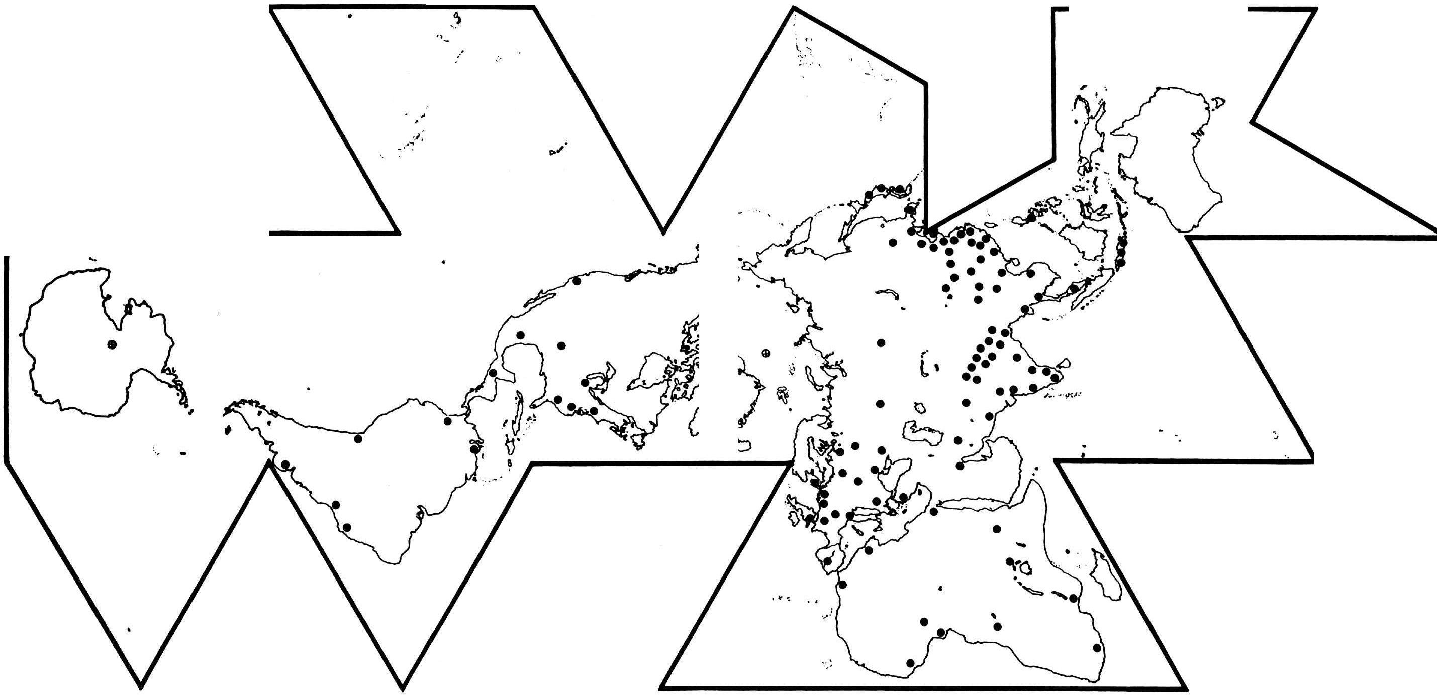
| South America | 6% |
| Central America | 1% |
| North America | 7% |
| Africa | 11% |
| Europe | 16% |
| Asia (Land 54%, Water 7%) | 61% |
88 Kipling wrote in 1900, ‘‘East is East, and West is West, and never the twain shall meet.’’ All who read him thought Kipling was obviously correct. No one in 1900 could foresee the as-yet-uninvented airplanes, let alone 350-passenger-carrying, 500-mph, intercontinental and around-the-world-flying jet airplanes, nor satellite-relayed intercontinental telephony, etc.
89 You can see on my map the enormous concentration of humanity in Java, Malaysia, and the Indonesian islands, as well as along the original ‘‘waterfront’’ areas of the Asian mainland. Together Burma, Thailand, Cambodia, Laos, and Vietnam are the beachheads of Austronesian islanders ‘‘landing’’ upon the Asian continent. Clearly that is where humanity first went inland and upland to the Himalayas, exploring the Mekong River toward its source. This extraordinary fact relates also to the last ice age and uniquely to the 8 percent of my world map known as the Orient, which contains the 54 percent of humanity.
90 Looking closely at this area we see the Indus River rising in the Himalayas and flowing westward to Karachi and then into the Arabian Sea. Then, starting in almost the same High Himalayan place as the Indus, we see the Ganges flowing initially westward, then turning eastward and flowing south of the Himalayas to the Bay of Bengal. Next we note the Brahmaputra River, originating within 100 miles of the sources of the Indus and Ganges and flowing first eastward, then southward, to penetrate the Himalayas, whence it flows also to the Bay of Bengal.
91 Then we note the Salween, the Mekong, the Yangtze, and the Yellow rivers, all starting from approximately the same geographical source atop the Himalaya Mountains (an area so small that my forefinger tip can cover it on my map). Thus 54 percent of humanity (over eight times the population of North America) is ‘‘watered’’ from the same ‘‘reservoir’’—the frozen Himalayan reservoir, which melts just fast enough to keep things growing and life going on through ages and ages and ages.
92 As the water-people came out of the ocean-island habitats and began to ascend those rivers and ‘‘carried aloft’’ their ‘‘canoes’’ around and above the rapids and waterfalls, they could not help eventually discovering the common regional source of this comprehensive life-support water.
93 In the present critical unrest of our world, where we find the greatest ideologically warring powers on our planet puppeting, through Vietnam, the dissensions into warrings of Cambodians, Laotians, Thais, and Burmese, it is clearly seen that the only differences between those Southeast Asian peoples are the rivers by which they go inland and upland—to the same source of life-supporting water. It is easy to understand why the Dalai Lama was located in Tibet, at the source of all their water. That source epitomized God as the physical life-giver and -taker.
96 Looking at Southeast Asia on a metallurgical resource display map and coming north in the Gulf of Siam to the mouth of the Chao Phraya River, we note that in the Malay Peninsula there are vast amounts of tin ore all the way from Singapore to Burma and northward inland in Thailand along the Chao Phraya River to northern Thailand.
97 Then, altering our direction, we go a short way eastward and descend from the mountains of Laos, which are every-where rich in copper ore. Everywhere along the east bank of the Chao Phraya River lies copper ore, and everywhere along its west bank lies tin ore.
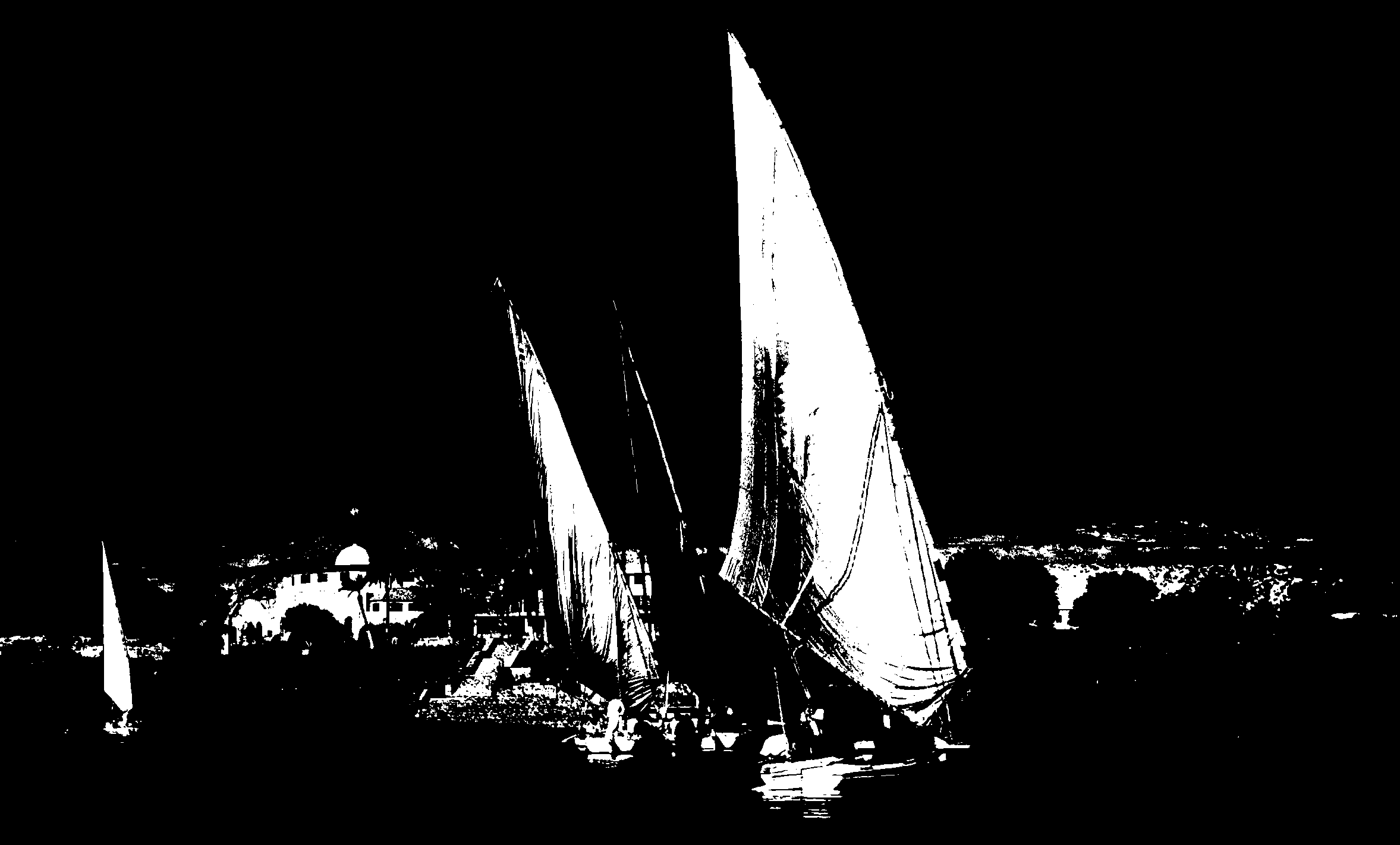
98 At Bangkok, on the Chao Phraya River, I find the most extraordinary history of the development of wooden boat-building as yet manifest on our planet. I remember how back in 1958, as I went along canals leading off from the Chao Phraya River, I kept discovering shipyards. In all America there are less than fifty boatbuilding yards now in operation. But in Greater Bangkok alone I saw more than 100 boatyards.
99 To the boatyards of the Chao Phraya River and its canals the logging people inland and upstream bring sea-ward (with the current and tides) great teak logs, which are towed together in enormous intertied rafts. As we get into the Bangkok region, we see the great teak log rafts moored wherever there is spare waterfront.
100 The shipbuilders usually keep the logs soaking for up to 100 years before using them in their ships’ hulls. After a century of soaking the teak becomes highly stabilized structurally. They then haul out and dry the logs sufficiently for their shipbuilders to work them into long planks and frames with their metal tools. In all my boatbuilding experience—of which I have had a lot—I have not found any craftsman sawing out long, delicately curved ship’s plankings and planing them with greater accuracy than in Bangkok. They make their planks so carefully that they fit watertightly together without any caulking. They dry the teak just enough to fashion it into ship’s planks, but the minute the ships are launched (for instance, as great rice-freighting hulls), enough moisture gets back into the wood to swell the planks watertightly together. (What also fascinates is the incredible amount of rice being brought out to feed civilization—stored sometimes for months in boats’ bellyholds, which are absolutely dry-tight and never painted.)
101 The Thais have had thousands of years of such boat-building experience. The entire evolutionary history of great boatbuilding is as yet manifestly alive on the Chao Phraya River. Every instance of the progressive stages of its evolution—from watertight teak bins mounted on rafts to the big-ribbed, deep-belly ships found in use there today—is in live operation.
102 Anyone who is a sailor knows that ships have to have powerful and enduring fastenings of many kinds-nails, screws, and rivets-to hold fast the teak planking to the ribs, and myriads of rope cleatings, chain plates, etc. Nothing could better serve as fastenings than non-rusting bronze. Those Thai sailors and boatbuilders were the first to accidentally marry copper and tin to produce bronze and thereafter to use it purposefully in shipbuilding. Copper’s first great structural functioning came when combined with tin as bronze fastenings in ships.
103 I am absolutely confident that Bangkok is the center of the beginnings of the best ship technology and design engineering of world-around civilization. Prototypes of every type of hull from gondolas to barges are there, including the prototypes of the powerfully ribbed, deep-bellied ships that the Phoenicians sailed across the Indian Ocean and to Mesopotamia, where the ‘‘Garden of Eden’’ story is played. When they attained big-rib ships, their sailors went readily out to sea whence their islanded forebears came. These improvements allowed them to go more directly into the wind. They could ‘‘beat’’ at a twenty-two-and-one-half-degree angle either side of the wind and ‘‘work to windward’’ rapidly.
104 The sea-going traffic extended at first to the Malay Straits, then spread out into the Indian Ocean. As the inter-change between different nationalities increased, so also each began to copy the best features of the others’ craft. The ships became composites of the sum-total experience gained throughout that general area. The merchants moved westward into the Indian Ocean (which has reverse winds during the monsoon), but by this time they could go counter to the breeze.
105 Thus it was that the dhow of the western Indian Ocean reached the Persian Gulf, the Red Sea, and the east coast of Africa. The men who as yet handle these dhows are extraordinary. They assume that their trade has been in continuous existence for at least 10,000 years. Their navigation must be meticulous. Considering the period that it would of necessity take to develop such vessels as theirs and to establish such a circulation, there is no reason at all to doubt their estimates.
106 Among ships the dhow still sails the sharpest angle into the wind. This is the advantage of the triangular lateen sail, with its long spar attached to its short mast in such a manner that their angle of incidence is forty-five degrees. The front of the spar is heavier than the rear end, which projects into the sky. The balance is so exacting, however, that the sheeting does not have to be very rigid and the mast can act as a fulcrum.
107 The dhow enabled sailors to go against the wind to a greater degree than they had ever done before. They could now sail to westward over great distances—against prevailing currents. Out of this remarkable skill came a new phase of ‘‘world’’ seafarers. No longer subject to the vagaries of the elements, they could make headway against them.
108 After many thousands of years eastbound man became westbound. The former gave rise to the Eastern philosophy of ‘‘acceptance,’’ which still persists. The latter was a new development and fundamentally altered humanity’s thinking. To the sailor God seems to be the prevailing winds and currents that carry one in a particular direction. To go against the wind or current, to ‘‘beat to windward,’’ is therefore a deliberate act against Him. Here began a concept of man being contrary to his God.
109 In the early drifting-with-the-current-and-prevailing-wind days a large migrating of humanity occurred within the Pacific. The rafting colonists were swept along the coast of China into the Bering Straits by the Japan Current. There a bridge of land between the continents contributed considerably to the overland migration from the Orient to the coast of North America. The Japan Current carried the rafters to Alaska. It carried them to Mexico and Central America. It carried them to Colombia, Bolivia, and Peru. Thereafter the same current swept them back westward across the Pacific back to Austronesia, as Thor Heyerdahl proved with his raft Kon Tiki. As sailing-into-the-wind people headed westward from the Malay Straits, they crossed the Indian Ocean, arriving in Mesopotamia and on the east coast of Africa. From there they traveled over-land to the Nile. Over 10,000 years of continuous voyaging across the Indian Ocean by the dhow sea captains evidences the deep-bellied, heavily keeled and ribbed engineering of their craft and its seaworthiness-and locates the origins of sea technology in the area of Ban Chiang.
111 All civilization had its origins in the network of maritime interlinkages of early
cultures. Tension-capability is newly manifest in seagoing-born tensional skill and
intellectual capability. Compressional capability is manifest of the land-born stone ages
and the inertia of stone walls. At sea humanity entered into true technology—that of
powerful tension-interfastening capability. Bangkok itself is the prototype of all canal
cities developed by later water-people around the world-for example, Venice and
Amsterdam. Sampans are prototypes of Venetian gondolas later brought, covered,
by the Phoenicians to Venice. (See map, page 136.)  Change: Add ref to map Bangkok seems to be the prototyping locale of the
big-keel, big-ribbed, deep-bellied ships of both the China Sea and the Indian
Ocean.
Change: Add ref to map Bangkok seems to be the prototyping locale of the
big-keel, big-ribbed, deep-bellied ships of both the China Sea and the Indian
Ocean.